1. Where the conditions imposed by the provisions of these regulations are either more restrictive or less restrictive than comparable conditions imposed by any other provisions of any other applicable local law, ordinance, regulation, resolution, rule or regulation of any kind, the regulation that is more restrictive and imposes higher standards of requirements shall govern.
2. The provisions of these regulations are not intended to abrogate any easement, covenant or other private agreement, provided that where the requirements of this regulation are more restrictive or impose higher standards or regulations than such easement, covenant or other private agreement, the requirements of these regulations shall govern.
3. No subdivision of land shall be made lawful solely by the adoption of these regulations if such subdivision did not lawfully exist at the time of the adoption of these regulations. If any existing subdivision of land is in conflict with these regulations in any manner, such subdivision shall remain unlawful until the requirements of these regulations have been complied with.
4. The provisions of these regulations are cumulative and additional limitations upon all other laws and ordinances therefore passed or which may be passed hereafter governing any subject matter set forth in the provisions of these regulations.
5. In the construction of these regulations, the provisions and rules of this Section shall be preserved and applied, except when the context clearly requires otherwise:
a. The singular number includes the plural and the plural the singular;
b. The present tense includes the past and future tenses and the future the present; and
c. The word “shall” is mandatory while the word “may” is permissive.
6. Any word or phrase which is defined in this Article or elsewhere in these regulations shall have the meaning as so defined whenever used in these regulations, unless such definition is expressly limited in its meaning or scope.
7. Words or terms not herein defined shall have their ordinary meaning in relation to the context.
Any word or phrase that is defined in this Section shall have the meaning assigned to it by said Section wherever the word or phrase is used in these regulations.
1. Access Control. The limitation of public access rights to and from properties abutting streets or highways. Access control is used to preserve high-quality traffic service and to improve safety.
2. Agriculture. The use of a tract of land for growing crops, pasturage, nurseries, dairying or the raising of poultry or cattle and other livestock, including the structures necessary for carrying out farm operations and the residence(s) of those owning and operating the premises such as a member of the family thereof or persons employed thereon and their families. The feeding or disposal of community or collected garbage shall not be deemed an agricultural use, nor shall riding academies, livery or boarding stables, dog kennels, commercial feedlots or commercial greenhouses; however, woodland and non-producing open space land are considered agricultural.
3. Base Flood Elevation. The highest elevation, expressed in feet above mean sea level, of the level of flood waters having a one percent chance of being equaled or exceeded in any given year (commonly called the 100-year storm).
4. Benchmark. Surveying mark made in some object that is permanently fixed in the ground, showing the height of that point in relation to North American Vertical Datum of 1988 (NAVD 88).
5. Blocks. A tract of land bounded by streets, or by a combination of streets, railway rights-of-way or waterways.
6. Building Setback Line. A line indicating the limit beyond which buildings or structures may not be erected. Such line may be more, but not less restrictive than applicable zoning or other regulations.
7. Dedication. Gift or donation of real property by the owner to a governmental unit. The transfer is conveyed by a plat or a written separate instrument. The act of dedicating is completed with a formal acceptance by the governing body.
8. Design Standards. The basic land planning principles established as guides or requirements for the design and layout of subdivisions as described in these regulations.
9. Detention Pond. A storage facility for the temporary storage of storm water runoff designed in such a way to limit the maximum discharge to an amount equal to pre-developed conditions.
10. Developer. The legal or beneficial owner or owners of a lot or of land proposed to be subdivided including the holder of an option or contract to purchase, or other person having enforceable proprietary interests in the land. (see also Owner; Subdivider)
11. Developer’s Agreement. A contractual agreement signed and notarized by the subdivider and the City or County, depending upon the location of the land being subdivided, which is conditioned upon approval of the final plat and acceptance of dedications thereon with primary concern for the installation and guarantees for public improvements.
12. Easement. A grant of specific property rights to land for the use of the public, a corporation or another person or entity.
13. Easement, Drainage. An easement required for the installation of storm water sewers or waterways and/or required for the preservation or maintenance of a natural stream or water course or other drainage facility.
14. Encroachment. Any obstruction in a delineated floodway, right-of-way, easement, building setback or adjacent land.
15. Frontage.
a. Street Frontage. The property on one side of a street between two intersecting streets (crossing or terminating) measured along the line of the street; or with a dead-end street, all property abutting on side of such street measured from the nearest intersecting street and the end of the dead-end street.
b. Lot Frontage. That portion of the lot that lies between the side lot lines and is adjacent to the street serving the lot.
16. Governing Body. The Mayor and City Council of the City of Haysville.
17. Improvements. All facilities constructed or erected by a subdivider within a subdivision to permit and facilitate the use of lots or blocks for a principal residential, business or manufacturing purpose. Improvements shall include all facilities listed in Article VII of these regulations.
18. Infrastructure. Facilities and services needed to sustain industry, residential, institutional, and commercial activities.
19. Lot. A portion of a subdivision or other parcel of land intended as a unit of ownership and occupied or intended to be occupied by one main building and an accessory building or a complex of buildings, including the open spaces and parking required by these regulations.
a. Lot, Double Frontage (a.k.a. Through Lot). A lot other than a corner lot, two opposite lot lines of which abut upon streets which are more or less parallel. On a Double Frontage or Through Lot, both street lines shall be deemed front lot lines, but in the case of two or more contiguous through lots, there shall be a common front lot line.
b. Lot, Reverse Frontage. A lot whose rear lot line also serves as the street line for a limited access highway or street.
c. Lot, Corner. A lot situated at the intersection of two streets. A lot abutting on a curved street or streets shall be considered a corner lot if straight lines drawn from the foremost points of the side lot lines to the foremost point of the lot meet at an interior angle of less than 135 degrees.
d. Lot, Through. (See Lot, Double Frontage.)
e. Lot, Interior. A lot whose side lot lines do not abut upon any street.
20. Lot Split. The dividing or redividing of a lot or lots in a recorded plat of a subdivision into tracts that meets the criteria established within these regulations.
21. Master Plan. Any plan or map adopted by the City for guidance of growth and improvement of the City and its environs including modifications or refinements that may be made from time to time.
22. Minimum Pad Elevation. The lowest ground elevation completely surrounding a structure or the lowest flood proofed opening into a structure. This elevation is expressed in city datum or mean sea level.
23. Open Space. An area of land or water, or combination thereof, planned for passive or active recreation or for protection, conservation or for preservation of natural resources, but does not include areas utilized for streets, alleys, driveways, or private roads, off-street parking or loading areas, or required, front, rear or side yards.
24. Original Tract. A tract of land in existence at the time, in 1969, that Sedgwick County adopted Subdivision Regulations. (July 1, 1969)
25. Owner. Any person or persons, firm or firms, corporation or corporations, or any other legal entity having legal title to land sought to be subdivided under these regulations. (See also, Developer; Subdivider)
26. Pedestrian Way (Crosswalk). A right-of-way across a block or providing access within a block to be used primarily for pedestrian traffic.
27. Petition. A legal instrument which serves as the basis for initiation of a public improvement project. A petition is frequently used during the platting process to guarantee the construction of certain improvements, e.g., street paving, water and sewer lines, drainage, etc. A petition is valid if its signatures are more than 50% either by area within the benefit district or by ownerships. Petitions are also used to initiate the vacation of streets, alleys, easements, other public reservations and plats.
28. Planning Consultant. Any person, firm, partnership, association, or corporation contracted to provide professional planning advice or service to the city.
29. Planned Unit Development (PUD). A platted parcel, subdivision, or district that contains specific zoning rules as a replacement for the adopted city regulations as approved by the governing body.
30. Planned Unit Development Plat. A plat containing additional language and depictions unique to one or more parcels contained therein, superseding zoning and subdivision regulations as approved by the planning commission and city council.
31. Plat. An engineering drawing/map of a tract of land which has been lawfully subdivided meeting the criteria established in the subdivision regulations and duly recorded in the office of the Register of Deeds of Sedgwick County.
a. Sketch Plat. A map or plan of a proposed subdivision made prior to the preparation of the preliminary plat to enable the subdivider to save time and expense in reaching tentative general agreements by a discussion of the form and objectives of these regulations.
b. Preliminary Plat. A tentative map or plan of a proposed subdivision of land showing the character and general details of the proposed development.
c. Final Plat. A map or plan of a subdivision prepared in accordance with these regulations to be placed on record with the County Register of Deeds.
d. Replat. A new plat of a revision to a subdivision or portion thereof for which a final plat has previously been recorded. Such plats are processed as new plats for preliminary and final plat review and approval.
32. Public Way. Any parcel of land unobstructed from the ground to the sky, more than 10 feet in width, appropriated to the free passage of the general public.
33. Reserve. An area of property within a subdivision that is platted for specific uses, e.g., open space, entry monuments, landscaping, recreational facilities, utilities and drainage, floodway, private street, etc. Typically, future ownership and maintenance responsibilities for a reserve is set forth by a restrictive covenant which provides that a homeowner’s or lot owner’s association will hold title to the reserve and therefore be responsible for the reserve’s maintenance. The restrictive covenant may provide for ownership and maintenance to be tied to the ownership of an adjacent lot. Ownership and maintenance is not assigned to an individual, partnership or corporation except in the case of a reserve platted for possible future sales to a public body for a public facility.
34. Restrictive Covenants. Contracts entered into between private parties which constitute a restriction on the use of private property within a subdivision for the benefit of property owners and to provide mutual protection against undesirable aspects of development which would tend to impair stability of values. Such restrictions may be set forth in a deed. Restrictions are also placed of record by separate instruments including homeowner association agreements. Restrictive covenants usually run with the land, and are not enforceable by a municipality.
35. Sanitary Sewers. Pipes that carry only domestic, commercial and industrial sewage and into which storm, surface and ground waters are not intentionally admitted.
36. Septic Tank. An individual sewage disposal system involving a water tight receptacle that receives the discharge of sewage from a building and is designed and constructed to permit settling of solids from liquid, digestion of the organic matter (sludge), and discharge of the liquid portion into an underground lateral disposal area. The sludge is pumped out of the tanks, usually by commercial firms, at regular intervals. Septic tanks are used for domestic wastes when a sanitary sewer line is not available to carry the wastes to a wastewater treatment plant. Approval of a site for use of a septic tank system involves establishing a minimum lot area to provide for the system’s operation, determining that the soil has an acceptable percolation rate and ensuring separation of the system from groundwater.
37. Setback Line. The line that is the distance that is required by the City of Haysville Zoning Regulations between a principal structure or accessory structure and the property line of the lot on which the structure is located.
38. Sewage. The total of organic waste and wastewater generated by residential, commercial and industrial establishments.
39. Sidewalk. That portion of a street or pedestrian way, paved or otherwise surfaced, intended for pedestrian use only
40. Stormwater Detention. Any storm drainage technique that retards or detains runoff, such as a detention or retention basin, parking lot storage, rooftop storage, porous pavement, dry wells or any combination of these techniques.
41. Street. The entire right-of-way width between the boundary lines of every way which provides for public use for the purpose of vehicular and pedestrian traffic, and the placement of utilities and including the term “road”, “highway”, “lane”, “place”, “avenue”, “alley” or other similar designation. Types of Streets include:
a. Alley. A public right-of-way along the side of or in the rear of lots intended to provide a secondary means of access to and from streets and such lots. An alley is not intended for general traffic circulation.
b. Arterial Street. Any street serving major traffic movements that is designed primarily as a traffic carrier between cities or between various sections of the city, which forms part of a network of through streets, and which provides service and access to abutting properties only as a secondary function.
c. Collector Street. Any street designed primarily to gather traffic from local or residential streets and carry it to the arterial system.
d. Cul-de-Sac. A short street with only one outlet and which is permanently terminated by a vehicular turn-around at its closed end.
e. Dead-End Street. A street having only one outlet and which does not benefit from a turnaround at its closed end.
f. Freeway. Any divided street or highway with complete access control and grade separated interchanges with all other public streets and highways.
g. Frontage or Marginal Access Road. A local street which is parallel with and adjacent to a limited access highway or arterial street and which provides access to abutting properties and protection from through traffic on the limited access highway or arterial street.
h. Half Street. A street bordering one or more property lines of a subdivision tract to which the subdivider has allocated only a portion of the ultimate and intended street width.
i. Local Street. Any street designed primarily to provide access to abutting property, to include lanes, drives, circles, boulevards, or any other designation that might be given to such streets.
j. Parkway Strip. That portion of street right-of-way that is not a part of the roadway driving surface and which is located between the back of the street curb, or edge of the improved roadway surface, and the street right-of-way line. The parkway strip provides unobstructed right-of-way for the installation of public utilities (typically gas and water lines), sidewalks, street signs, street lights, street furniture, street trees, emergency call boxes and other ancillary uses. The parkway strip should not be confused with parking lanes that are often provided as part of street pavement. The parkway strip is sometimes called a street’s side strip.
k. Private Street. A right-of-way or easement which affords principal means of vehicular access to property abutting thereon, which right-of-way or easement is owned, controlled and maintained by persons other than the public.
l. Street Stub. A short section of street right-of-way platted to provide future access to an adjacent unplatted tract of property
42. Subdivider. The owner, or any other person, firm or corporation authorized by the owner, undertaking proceedings under the provisions of these regulations for the purpose of subdividing land. (See also, Developer; Owner)
43. Subdivision. Any division or redivision of land by means of mapping, platting, conveying, changing or rearranging of boundaries, or otherwise, and shall also relate to the process of subdividing or other land subdivided where appropriate to the context.
44. Turn Around. An area at the closed end of a street with a single common point of ingress or egress (cul-de-sac) within which vehicles may reverse their direction without any backing up movements.
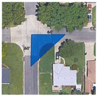
45. Sight/Vision Triangle. A triangular area on a lot that is located adjacent to the area where two streets intersect. The triangle has two sides measured from the center of the right-of-way, and a third side across the lot which connects the ends of the two sides. In all districts, the two lot lines establishing the sight triangle shall be a minimum distance of 60 feet. However, such standards may be increased to reflect unusual topography, sight distance, angle of street or roadway, vegetation or intensity of traffic volumes or speed. At street intersections, which are provided automatic traffic signalization, the Administrative Committee may modify or waive the sight triangle restrictions. The Zoning Administrator shall determine, upon request, the location of any sight triangle.
46. Waterway. Any natural or artificial stream, river, creek, ditch, channel, canal, conduit, culvert, drain, waterway, gully, ravine or wash in which water flows in a definite direction or course, either continuously or intermittently, and has a definite channel, bed and banks, and includes any area adjacent thereto subject to inundation by reason of overflow or flood water.
47. Wetland. A land area that is saturated by surface water or ground water at frequencies and durations sufficient to support a prevalence of plant life typically adapted for life in saturated soil conditions and as defined in Section 404, Federal Water Pollution Control Act of 1972 as amended, and delineated on maps prepared by the U.S. Fish and Wildlife Service and as field verified by on-site inspection.